
Hugbúnaður fyrir GIS

Leica Zeno Office
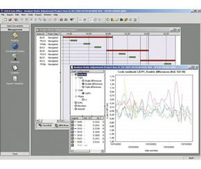
Leica Zeno Office on ArcGIS™ provides a set of tools for managing and processing GNSS and surveying data within ArcGIS Desktop, all from directly within your familiar environment. Leica Zeno Office is a software package to maintain, manage and post-process GIS, GNSS and surveying data.
With Leica Zeno GIS you get much more done in a busy day and have full trust in the accuracy of your GNSS data.
Automated field-office workflows: EasyIn and EasyOut
Store detailed GNSS quality information in a GIS database
Integration of surveying measurements in a GIS database